Is the NMMA's 'Manhattan Project' To Save Whales for Real, or Is It Theater?
Getting Answers to Simple Questions Turns Into an Easter Egg Hunt
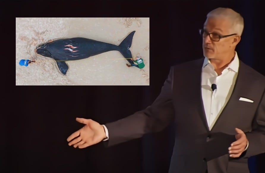
Loose Cannon was one the earliest advocates of a tech solution. Eighteen months later, no one wants to talk.
The National Marine Manufacturers Association calls it an “interaction” when a boat slams into a North Atlantic right whale and kills her. Using a euphemism for “whale strike”1 is language NMMA uses in its campaign to prevent government from imposing vessel speed limits when these endangered animals are in the neighborhood.
The National Oceanic and Atmospheric Administration could enact new regulations any day now, but the agency is under fire for allegedly slow-walking its decision.
Simply put, existing 10-knot speed limit zones—seasonal zones—would be expanded to include all boats over 35 feet long on the U.S. East Coast coinciding with right whale migration patterns. As it now stands, only vessels over 60 feet LOA must comply.
Predictably, marine interests have framed the issue in apocalyptic terms. “In Atlantic coastal states alone, 63,000 registered saltwater fishing boats are impacted, and 340,000 American jobs and nearly $84 billion in economic contributions are in jeopardy if this proposed rule moves forward,” NMMA President Frank Hugelmeyer told Congress in June 2023.
The real solution, according to Hugelmeyer, is technology. He and his communication staff beat that theme like a drum, but without going into much detail. The closest thing to a description of what the whale-saving technology would like came in Hugelmeyer’s extensive testimony to a House committee.
In September 2022, Loose Cannon pretty much broke the story about NOAA’s push to expand offshore speed limits. The story also noted that the government was already using AIS to enforce them for boats already subject to speed restrictions. That is, the over 60-footers. Here’s a link, in case you missed it:
In a follow-up story, Loose Cannon also explored the possibility of using technology instead of speed limits to reduce the risk of whale strikes.
Many commenters on the Federal Register, where the new NOAA Fisheries rules are being previewed, and on Facebook, where the Loose Cannon story was promoted, argued that AIS could be used to better delineate the boundaries of today’s existing (smaller) go-slow zones. By now, most of us are familiar with these so-called Virtual AtoNs (aids to navigation) projected onto our chartplotters via AIS.
Tantalizingly, some commenters suggested that AIS should be used to track and broadcast the locations of the right whales themselves, which would require that GPS Lat-Lon transmitters be attached to the animals, and the location data collected by satellite then broadcast like a virtual AtonN . That way, boaters with AIS receivers could slow down in the vicinity of right whale congregations or avoid them altogether.
So you can understand Loose Cannon’s interest when the NMMA began to make repeated references to a technological solution to the problem, even as boat strikes continued to kill more right whales and a coalition of environmental groups were reopening a federal lawsuit against NOAA, demanding speed limits now!
Five Dead or Presumed So
Florida Fish & Wildlife, a lead agency studying the plight of the right whale, put that sense of urgency in perspective recently:
April 15th marked the end of an eventful right whale calving season. This year, a total of 19 calves were sighted in the Southeastern U.S., the calving grounds for the species. Although this number was better than observed during several recent winters, it needs to be higher, and those calves and breeding females need to survive and remain healthy. The population previously has shown that it can grow and persist if human-related stressors such as entanglement in fishing gear and vessel strikes are mitigated. Unfortunately, one of the calves died following a vessel strike, and four more are presumed dead after they went missing.
In 2023, NMMA and industry partners established a Whale and Vessel Safety Task Force to find a solution that didn’t force every planing hull to be throttled back to displacement speeds through big swaths of ocean part of the year.
Addressing the House Natural Resources Committee, Hugelmeyer summarized techniques that the WAVS Task Force was considering.
Technology that can deliver real-time monitoring of individual right whales continues to advance. From direct observations, aerial surveillance, acoustic detection, heat signature technology, satellite monitoring and ambient DNA signatures found in water samples, it is feasible to gather real-time location information on a significant portion of the right whale population. Fewer than 350 individual right whales remain, which makes tagging or other high-value monitoring techniques possible. If all right whales cannot be tagged or monitored, perhaps efforts could be focused exclusively on mature female right whales, roughly 100 individuals, to protect the most reproductively valuable segment of the population.
Even if monitoring of all right whales is not possible, we can expect any real-time monitoring to provide ancillary protection to non-monitored right whales because of their grouping behavior…Outreach could also be conducted with the recreational fishing and boating community on ways they can provide direct observations of right whales to NOAA.
The second key portion of this effort is the need to disseminate information to mariners and other vessel operators. Distributing this information to anglers and boaters and into their marine electronics is essential…Our industry would welcome developing ways to provide real-time positioning on navigational hazards, including right whales, to vessel operators.
The WAVS website, described as a “Viking Yacht Company inititiative” brings the issue a bit more up to date. There’s lofty rhetoric, a vague Q&A, and some news releases that list an executive at Viking2 as a contact for further information. There are also PDF copies of 10 pertinent scientific papers, including four on satellite monitoring, four on sonar and one about the use of thermal imaging.
The latest news release was posted in March. It was a summary of discussions at a recent WAVS workshop with NOAA officials about how to refocus existing technology to prevent whale strikes.
The goal of WAVS is to develop a system to identify places in the ocean where the whales are actually present, instead designating wholesale go-slow zones that stay in place for weeks or months at a time. Once identified, these actual whale locations would be communicated to nearby vessels, which would then slow down until they were clear of the whales or avoid the area altogether.
WAVS Task Force Chairman John DePersenaire gets points for not using the term “whale interaction” in that news release:
Utilizing marine electronics commonly installed on a broad range of vessels is critical to receiving and transmitting NARW information to reduce vessel strikes. Thermal imaging technology coupled with artificial intelligence software, for instance, will allow mariners to identify whales directly on their multi-function display and notify others through communication tools such as AIS (Automatic Identification System).
DePersenaire suggests that this thermal imaging might be something that could be used on your average 30-knot sportfishing battlewagon, but the scientific paper that included the above illustration seemed to contradict that notion that a system was an effective substitute for speed limits.
“We found that in slow-speed environments, such as speed-restricted zones, vessel-based whale detection systems for strike mitigation could provide a high level of protection for the animals,” researchers wrote. In other words, the system is less effective at high speeds.
Text Messaging
DePersenaire’s news release obliquely referred to an effort in Massachusetts, in which a public-private coalition found a solution to the second half of the tech solution—the part where known whale locations are communicated to nearby boaters.
In this experiment, coordinates for feeding whales were first established by aircraft reconnaisance. The Cape Cod Times takes up the story:
At the end of January, staff at Stellwagen Bank National Marine Sanctuary and Maritime Information Systems, Inc., in cooperation with the U.S. Coast Guard First District out of Boston, successfully transmitted a text message directly to the bridge of a large tanker informing the navigators they were exceeding the speed limit within the Cape Cod Bay NOAA Right Whale Seasonal Management Area.
The message, which read "Max speed 10 knots per 50CFR224.105-31," was sent by way of the ship's Automatic Identification System receiver and charting system display. AIS receivers are navigation safety devices that transmit and monitor the location and characteristics of many vessels in federal and international waters in real time, according to the National Centers for Environmental Information, a division of the National Oceanic and Atmospheric Administration.
In response, the team got a message acknowledging that someone aboard the vessel successfully received the speed limit text. Since then, the system has sent about 40 other speed advisories to vessels crossing the Stellwagen Bank sanctuary, a 842-square-mile underwater reserve that spans the mouth of Massachusetts Bay from Jeffrey's Ledge off Cape Ann to Race Point Channel off Cape Cod.
While it may be disturbing to libertarians, the technology is in place to send conventional text messages to any mobile phones pinging cell towers from locations on coastal waters where whales are.
Human-in-the-Loop
Another promising tech solution was not mentioned in the news release but which can be found by reading the WAVS website, and it involves a Canadian company called Whale Seeker, whose methods have been shown to work with other whale species.
Whale Seeker, which is a member of the WAVS Task Force, has a computing tool called Möbius, which uses artificial intelligence to quickly analyze huge numbers of aerial ocean photos.
Co-authored by Whale Seeker people and Canadian fisheries researchers, a scientific paper published in Frontiers noted the challenges of analyzing aerial information from “terabytes of photographs” quickly enough for time-sensitive applications.
The paper describes applying AI to narrow down images to a number sufficiently manageable for “human-in-the-loop” confirmation. “Using computing power instead of total human analysis also allows more data to be analyzed in a dramatically shorter time period, allowing more meaningful time sensitive decisions,” the researchers wrote.
Running the Clock?
All the above was gleaned without a single human interaction—there’s that word again—even though the NMMA has a veritable platoon3 of communication staff under Ellen Bradley, senior vice-president for Marketing and Communications. Neither she nor other staff members responded to emails from Loose Cannon, which is just plain rude.
The people at Whale Seeker were comically unresponsive, but at least there was a reply. Maria Galvao’s email might has well have said, “Sorry, everyone here is doing their laundry right now.”
Thank you for reaching out and expressing your interest in Whale Seeker. Regrettably, we find ourselves unable to pursue collaboration at this time due to existing commitments and pressing deadlines demanding our attention. We genuinely appreciate your understanding and hope you have a wonderful weekend.
Ultimately, when there is an issue of public concern and all the messaging is one-way via press release, the proper response should be skepticism. “Soon there will be a clear path forward,” one WAVS scientist was quoted as saying. Really? What does he mean by soon? Next year, five years from now, Fourth of July 2030?
In this case, the reason to interview live people is to ascertain what concrete steps are being taken to find a substitute for ocean speed limits—that old who, what, where, when and how. Without an ETA for D-Day, how can we get a sense of gain versus pain? As in, how many whales would be likely to die if we wait for the NMMA Manhattan Project to bear fruit instead of expanding speed limits?
When folks won’t answer questions, they invite speculation: Is all this talk of tech just some kind of theater—a grand delaying tactic? Are speed-limit opponents just hoping that the next U.S. administration will be more sympathetic to sportfishermen and less so for whales?
One of the first stories I ever covered as a newspaper reporter was a horrible thing. A toddler had figured out how to open doors without his parents realizing it. One day he went outside, walked into the road and was killed by a car. I shot the news photo of the front of the vehicle with its one shattered headlight from impact with the child’s skull. By NMMA logic this family tragedy would be filed under “auto-infant interaction.” The destruction of the bridge in Baltimore would be a “ship interaction.”
Ocean speed limits is almost entirely an issue for sportfishermen and the sportfishing industry. Ten knots is a speed that sailboats and most trawler yachts can only aspire to. Viking Yacht Company is the most influencial sportfish manufacturer in the world, turning out 80 boats betwen 40 and 82 feet LOA a year, for a total of more than 5,500. The other major constituency opposed to speed limits are owners and the many builders of center console boats. Center consoles are riding a wave of popularity after what is seen as the recent near perfection of outboard motor technology.
Okay, not a platoon. More like a squad: