Highway to Hell: Autopilot Assisted Disaster
Examples of What Happens When Available Tools Go Unused
This article originally appeared on May 4 for paid subscribers.
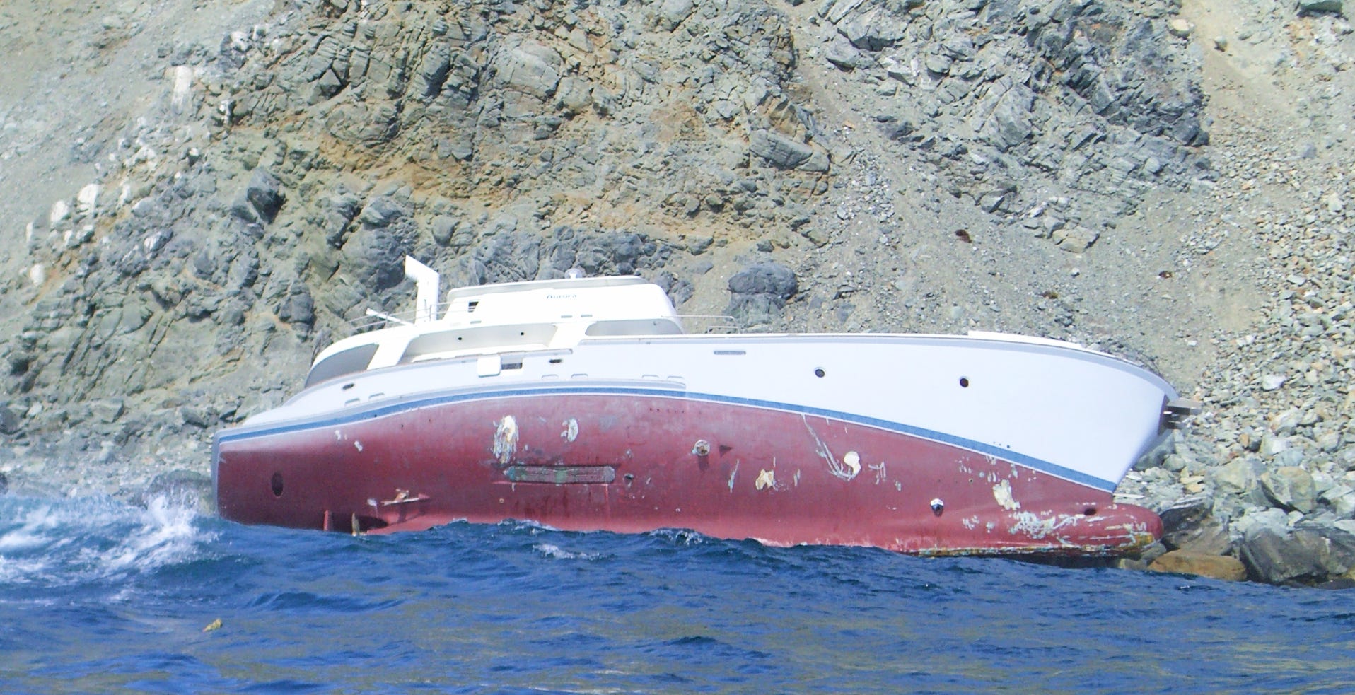
Having a lot of leeway in the working world is a good thing, right? It means freedom to act or make decisions. For passagemakers, however, leeway is Satan. Leeway is the sideways drift from the desired course set for your vessel. This story is about three cases of leeway, two of which ended in disaster and a third which might have, were it not for dumb luck.
The lucky one was me, so let’s start with my splendid adventure sailing back from Nova Scotia.
Sailing a 30-foot Bermuda Ketch named Hong Kong Maiden, we took a three -week cruise from Massachusetts to Nova Scotia with the intention of returning along the Maine coast. This was in the early 1990s, and we were still navigating by dead-reckoning.
The voyage was eventful from the beginning. The engine overheated as we were leaving Newburyport, Massachusetts, but we decided to proceed to Halifax under sail alone—about 350 nautical miles—and only replaced the impeller once we got there.
The real crisis occurred as we were motorsailing back to the states. We could have been killed, but never even realized it until the moment had passed.
“You should see a light to starboard,” I told my watchstander, as I tucked in below to sleep. Its source would be the lighthouse at Seal Island, and the chart showed a lighted buoy about a mile south of the lighthouse. The boat didn’t have an autopilot, but my helmsman, a New Zealander, was pretty darn close. He could keep a boat on course better than anyone I knew. His concentration and stamina compensated for a slight deficit in critical thinking. Kiwi-pilot, you might say.
The next morning, Kiwi-pilot gave me the news. He had seen the light, and we had taken it to port. You could have hit me with a brick. The red line below shows our path.
You’ve seen pictures of wharfs and waterfronts in the Bay of Fundy. Boats shown lying on fields of muck by an outgoing 20-foot tide, with towering piers and bulkheads in the background. All that water moves in and out of Fundy two times a day. The current was moving into the bay when Hong Kong Maiden was rounding Cape Sable on a compass heading perpendicular to the northward flow.
“Why didn’t you wake me up? Didn’t you realize what was happening,” I scolded. The current had swept us sideways even as Kiwi-pilot rigorously kept the bow pointed toward Matinicus Rock in Maine. We had passed between Seal Island and the island just north of it. However, even as the words were coming out of my mouth, I realized that it was maybe a good thing that Kiwi-pilot’s alarm feature was set to mute.
My arrival in the cockpit in pitch black might have ended badly. I would surely have tried to do something to correct our mistake, and that likely would have driven us onto the ledges waiting all around us. As it were, the boat went with the flow and came out safely on the other side.
Later I did the research on the place. From one history:
The island was settled in 1823 by two families from the Barrington area, the Hitchens and the Crowells. They used the island as a fishing base and provided shelter to survivors of the many ships wrecked at the island and on nearby reefs. A campaign led by Mary Hitchens resulted in the construction of a lighthouse in 1831 which still stands, one of the oldest wooden lighthouses in Canada. Seal Island lightkeepers continued to rescue many shipwreck victims, most notably in 1843 when they saved all the crew and passengers of RMS Columbia, one of Samuel Cunard's first ocean liners.
Credit Mary Hitchens because you can bet some of her neighbors had preferred to carry on a tradition of plundering wrecks to supplement an otherwise meager living of fishing and hardscrabble farming.
Paper charts for currents in this area weren’t commercially available back in the 90s, but I knew it was important to have them. I scored a set from the marine researchers at the University of New Hampshire. Black arrows were timed to high and low tides at Boston Harbor, as noted in the annual Eldridge’s Almanac, a book we all carried back then. The size of the arrows indicated current strength in knots.
Hong Kong Maiden didn’t carry radar; chartplotters had not been invented; autopilots were rare in small craft. We did have a primitive sounder and a VHF radio. We navigated using a wet compass, charts, parallel rules and dividers and an accurate wristwatch. Thanks to UNH, we knew which way the current was going and when.
The conservative play would have been to round Cape Sable to coincide with an outgoing tide or just prior at slack before an outgoing tide. That way we would have been pushed away from hazards instead of toward them. We didn’t have a lot of technology compared to nowadays, but we had a key resource that we failed to use. That we escaped any consequences did not erase the fact that incompetence had taken a routine, low-risk ocean passage and turned it into a running of the gauntlet.
The next two case studies happened after the arrival of marine electronics that seemed near miraculous at first. Yet, despite this advantage, the people involved seemed likely to have made the same basic error but without my luck.
Nordhavn 62 on the Rocks
The name of the boat is the Charlotte B. The location is the Pacific coast of Baja Peninsula in Mexico. Baja begins at the U.S. border just south of San Diego and spans about 750 miles to its tip—about the size of Italy. The wreck, as pictured at the top of the story, happened on April 18, 2006.
There are four people on board: Brian Saunders is the Coast Guard-licensed skipper; Jim Hartwell, also licensed; and Mark and Sue Sanders, a married couple (not related to the captain.) Hartwell, according to court documents, was at the helm when the wreck occurred.
The Charlotte B. is a Nordhavn 62, built in 2000. Her passage back to the U.S. was a paid delivery on behalf of absent owners.
According to one account, the was a 35-knot northwest wind on the night she wrecked. Waves and winds on the West Coast tend to come out of the Northwest. Consequently, the transit northward is often referred to as the “Baja Bash.” If a vessel loses propulsion enroute, even in calm conditions, it will eventually end up aground unless an anchor grabs.
No mechanical issues were reported at the time of the wreck. A Nordhavn 62 is built to circumnavigate; 35-knot winds would not have been enough to overpower her, though they would have been a factor in her making leeway east of the intended course. Big and heavy, a 62 is not the kind of boat that is hand-steered except during close quarters maneuvering, barring autopilot failure.
Presumably, then, Charlotte B. was running on autopilot on the night of April 18 with Hartwell at the helm.
About 10 years ago, Brian Saunders declined to participate in a story about the accident, so I shelved the project until now. Based on public record and research by by a third-party mariner named Mike Maurice, the likely cause of the accident was due to some combination of navigational failures:
Setting the autopilot to hold a magnetic compass heading, without programming a waypoint into the chartplotter. That is, autopilot in dumb mode. Then not paying attention to the actual course made good by observation or GPS location.
Programming a waypoint but not activating the tracking feature on the integrated autopilot—again, running in dumb mode—while also failing to monitor the plotter for cross-track error, or
Failing to activate an alarm feature on the plotter that would have notified the watchstander that leeway had exceeded a programmed limit, say, 2/10 of a mile.
Failure to monitor the depth sounder, whose alarm feature also could have alerted the watchstander that the boat had entered waters where the depth was less than, say, 300 feet. The coast of Baja may be poorly charted but staying in deep water avoids any hazards.
Failure to monitor radar: The bold shores of Baja make for strong returns, making radar an excellent tool for maintaining an interval from the coast in the absence of accurate charts. Modern units allow an operator to set an alarm to warn if the vessel comes within, say, two miles of the shoreline.
“What is not in dispute is that the boat went aground, and one could draw reasonable inference that the boat was in fact too close to the coast. The charts for the area are marginal at best along the entire Mexican coast inside of 60 or so feet of water,” Mike Maurice wrote on a popular trawler forum.
I had made the same transit a couple years earlier delivering a 37-foot trawler. She was equipped with a decent electronics suite, and I was sufficently chastened by my near-disaster off Nova Scotia to use it. Given the brisk onshore wind, skipper and watchstander should have been hyper-aware of leeway. Steering Charlotte B. onto the rocks had happened because of what can only be described as a spectacular failure to use available technology. And the outcome was tragic.
Charlotte B. was aground and being roughed up by surf when, according to court papers, Mark Saunders got off the boat to run a line to somewhere or something. He never made it. Raised by a wave, the 155,000-pound vessel came down on him like a hammer, and he died in front of his wife.
His widow sued the owners of the vessel, who had hired the captain and, by extension, the crew. The case was settled without going to trial. One of the arguments she had made, through her lawyers was that Mark Saunders had died due to the failure to furnish “a fit, proper, adequate and/or sufficient crew.”
There was some online chatter about the vessel having hit an “unchartered rock,” but a year and a half later, two boats ran down the same coast in daylight, one a half mile, the other a mile offshore, and neither saw any indication of the rock in question. Even if a mystery mini-mount were to be found within a mile of the shore, that would raise the question: Given 35-knot winds, why didn’t they stay two or three miles or more away from a dangerous lee shore? (I’ll say more about “uncharted” features in the section below.)
1986 Hans Christian 43 Abandoned in Cuba
Satori was a 1986 Hans Christian, whose owners were taking her from Florida back to their home state of California. David and Anita Laurence and two other people were on board when they ran onto a reef off the Coast of Cuba on March 10, 2013.
Satori, which is a Japanese term for “sudden enlightenment,” was paralleling the northwest coast of Cuba on a course to the Yucatan Peninsula. Favoring the Cuban coast avoids the strong northeasterly current through the Straits of Yucatan, which then becomes the Gulf Stream. In fact, there is often a countercurrent that favors vessels sailing west. It worked for me on a trawler delivery in 2003.
Wind was brisk and the boat was thundering along at 7 knots in a thousand feet of water. Satori struck coral somewhere on the Colorado Archipelago, a 62-mile-long fringing reef and graveyard for hundreds of Spanish merchant ships during its empire. It must have felt like a car wreck.
The Laurences told me they had hit an “uncharted reef.” “What we found out later was that the area had not been charted in years, and the last time it had been charted was by the Russians,” Anita Lawrence said.
When people say something that isn’t charted, my inner skeptic hears, “We didn’t have that chart” or “We weren’t looking at the chart.” Cuba has the most up-to-date charts in this hemisphere, its hydrography certainly better than our own because it is based on soundings as recent as the 1980s. The Russians did not want their submarines running aground during the Cold War.
The region of Cuba by the Colorado Reefs is the most lightly populated in the country. The waters are lonely. No one responded to the Laurence’s radio calls at first. Then the Cuban Coast Guard sent divers from a nearby resort with lift bags, but Satori would not budge.
Finally, the Cubans sent a tugboat from a hundred miles away, and it dragged Satori off the reef and towed her to the nearest Coast Guard base. The boat had been hard aground for three days. With a breached hull and a water-soaked, non-functioning engine, Satori remaind tied to the dock, and the Laurences took a flight back to the U.S. to regroup.
That’s where I came into the picture. Satori had staged her West Coast delivery from Holland Marine, a boatyard in Green Cove Springs, Florida, that also does work on my boat. That’s how I learned the story about how the Hans Christian had come to be abandoned in Cuba. Coincidentally, I happened to be going to Havana in a couple of weeks on some journalism business, so I called the Laurences and told them I would look into the status of their boat.
The Cubans assured me that their Coast Guard had no interest in keeping the boat and that the salvors just wanted payment for the tow. I volunteered to bring the boat back to Florida for repairs. We’d patch the hull, get out a tow outside the reef then ride the Gulf Stream under sail to a rendezvous with a towboat to get us into harbor.
For a reality check I called the Sea-Tow’s corporate headquarters. The higher-ups there said the $10,000 towing bill was actually pretty reasonable, given the circumstances. Now, I needed reassurance from Cuba that there would not be any additional hidden fees, such as the coast guard demanding payment for storage. (Where Americans are concerned Cuba was—and is—a cash-only society.) I got no such assurances, no answer actually, so I advised the Laurences they should forget about recovering Satori and make an insurance claim for the loss.
I recall some talk about the insurance company questioning the qualifications of the Laurence’s passage crew—a level of experience had been stipulated in their policy—but eventually a settlement was reached.
So how did Satori find herself on a chain of reefs marked with several lighted beacons? A brisk beam-reach is going to induce some degree of leeway, which somehow went unnoticed while the vessel sailed parallel to the reefs, most likely on autopilot. A programed waypoint, or even paying close attention to the boat’s position on the chartplotter, should have alerted the helmsperson that Satori was making leeway. The scenario was a rerun of the Charlotte B. debacle.
Certainly, a depth sounder alarm set to 300 feet would have alerted the helmsperson that a starboard turn was necessary.
Radar then might not have detected a reef awash. Certainly, today’s radars would, if tuned correctly.
An alert crew would have noted the lighted beacons, if they were working. And they might have heard the sound of waves breaking over the reefs in time to steer away.
Losing the life of a crewman or losing a boat is an awful punishment for lazy piloting. Nowadays, even a minor bad outcome can be hugely embarrassing when the photos are broadcast over social media. Leeway is an insidious enemy.
Highway to Hell: Autopilot Assisted Disaster
I was in La Paz when Charlotte B was there. Had New Year's Eve dinner with Brian Saunders 12/31/2005. We cruised south along the West coast of Mexico's mainland for a while then headed back North into Sea of Cortez and along East shore of Baja to Puerto Escondido. There we met up with boater pals we knew from La Paz in 2005. They were long-time, very close friends of Mark and Sue Saunders. This couple is very responsible and experienced, not given to hyperbole. They told us that Sue told them what happened. Sue said they picked up "Jim" while cruising south. I don't remember for sure if it was Cabo San Lucas, but think it was. Once they were underway, Jim supposedly informed everyone that he didn't need or use radar or modern gadgets to cruise. I don't remember every detail our friends told us. Unfortunately the parts I do remember are horrific and unnecessary to repeat. The bottom line is it was a completely avoidable disaster due to gross negligence that Mark and Sue were not a party to.
Interesting article, as always. The photo of the young you in the primitive 80's at the end reminds me of that time and a short story I just had published in SAIL magazine, June 22. If you don't get that rag, I can send you a scan of it.