

Explainer: Navigational Realities Behind the Strait-of-Hormuz Standoff
Terrain Analysis Complete With Maps, Charts and Photos

The author is a boatbuilder, a former Navy SEAL and author of dystopian thriller fiction (Scroll to the bottom). This story was first published on May 5, 2026 in Matthew’s Substack and is reprinted here with permission.
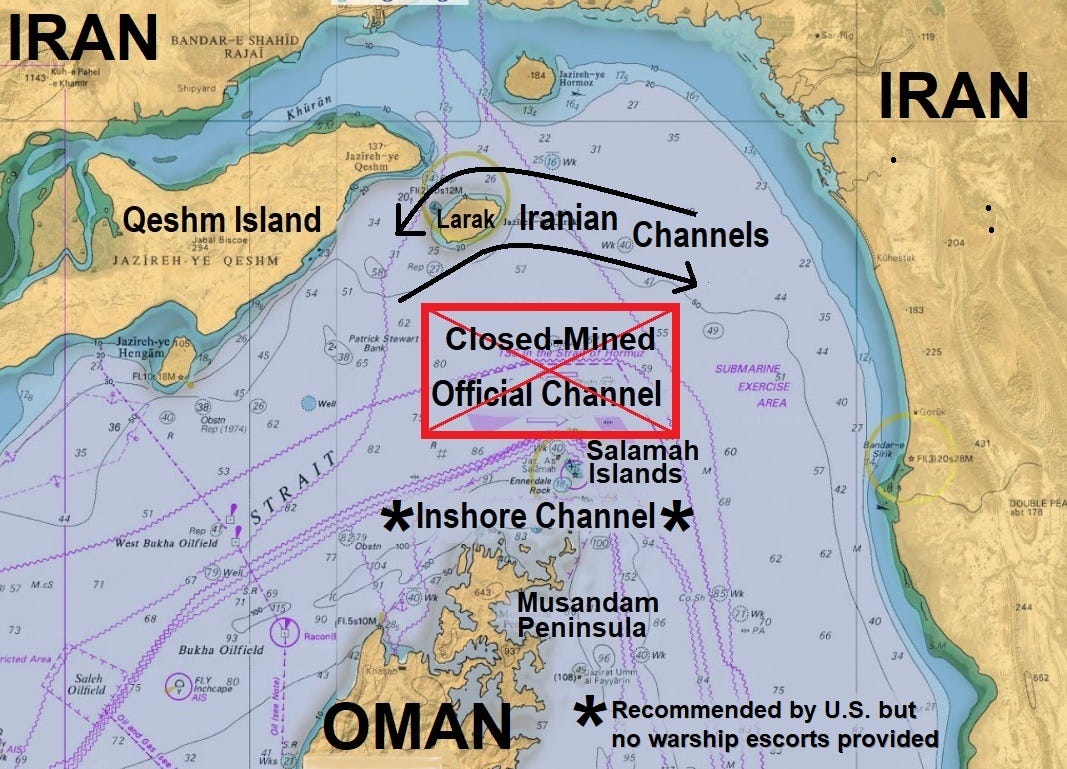
After following the latest news from both sides, and listening to this morning’s Pentagon brief, it’s becoming clear to me that the new American “safe passage guidance” plan is to steer shipping through the inshore southern “local traffic” channel near Oman. Jazirat Salamah is the northernmost outcropping of Omani Territory and guards this inshore shipping channel.

The chart below shows the entire Strait of Hormuz. The old official inbound and outbound channels ran through the middle. The current Iranian “toll route” is on the northern side in Iranian waters, and inbound ships must gain approval and then pass between the two Iranian islands shown. Outbound ships must also gain approval, and then pass near to Larak Island. Iran has implied that the center of the Strait of Hormuz has been mined, and the only safe route is the Iranian toll route.
This morning General Caine wasn’t explicit, citing operational security reasons, but it seems clear to me that he is suggesting that shipping will be kept safe if it passes through Oman’s inshore channel. For now it appears we will not be sending our warships through it, but we will put a total safety zone above and around it using our persistent surveillance and air power.
It remains to be seen if any non-U.S. ships will take up the offer to run through the inshore passage, without the physical presence of U.S. warships confidently escorting them, and sharing their danger.
(I’m still unsure if our Burke-class DDGs, the Truxton and the Mason, actually entered the Persian Gulf via this southern route on May 4, or where they were when and if they were engaged by Iranian fire. The two American ships that escaped seem to have used this Omani inshore channel.)
Below is the chart that Pete Hegseth and General Caine put up this morning. Note the crude free-hand green lines that are “Pentagon level and ready for the press.” It really does not give one confidence that this is a well-thought out plan.

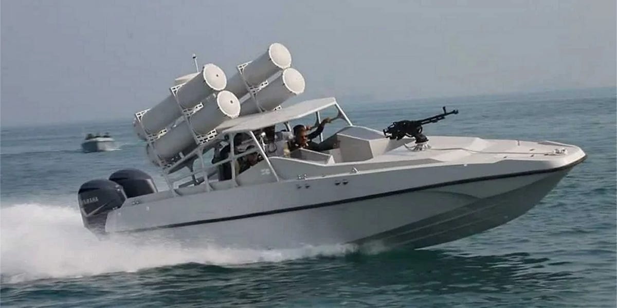
The problem is that the most important ships that are blocked inside the Persian Gulf are the giant VLCCs. These are Very Large Crude Carriers, and they can carry about TWO MILLION barrels of oil.
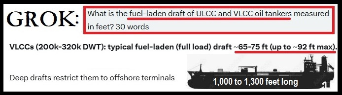
These ships are longer than our nuclear aircraft carriers, and 3 times as heavy. They take miles to plan their turns. With drafts of up to and 80’, they want to stay in very deep water at all times. This is even more true when they are low in the water and fully laden with their cargo of crude oil, which makes them even more difficult to turn, not to even mention to stop.
This is why it’s helpful that the mandated Iranian outbound route passes on the open water side of Larak Island, for easier and safer maneuvering by fully laden tankers.
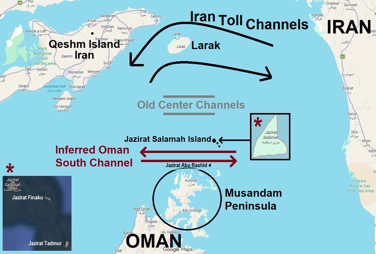
Next, take a look at the Inshore Traffic Zone on the chart below. Note the location of Jazirat Salamah. (Jazirat is Arabic for Island.) It used to mark the south side of the old official outbound traffic channel. South of Salamah are two other smaller rocky islands, and then Ennerdale Rock, which comes up to within 50 feet of the surface of the water.

As we have just seen above, tankers need much more than that depth. And a hidden rock is even worse than a visible island that shows up on radar. So only local smaller traffic (motorized dhows and so on) are going to pass north of Ennerdale Rock.
From Ennerdale Rock to the next tiny islet to the south is only 7.5 KM or 4 nautical miles. This area is notorious for tricky currents swirling around in eddies due to the underwater topography as the tides pour in and out of of the Persian Gulf. And it can also get windy here. Put a 20-knot wind against or sideways to a 3+ knot current (that shifts direction relative to the ship’s forward movement) and you have a channel that prudent mariners handling large ships will avoid at all costs.
This is why the official traffic channels were right in the deep and wide middle of the Strait of Hormuz, where these tricky currents are not as hard to predict or to understand, and thereby to compensate for. Note that the old inbound channels were each miles wide, with miles between them, and miles of buffer outside of them.
I can only imagine that ship traffic taking the inshore route, under optimal conditions, free from risk of missiles, drones or mines, will move in one direction at a time only, like the Suez Canal. There is no way that a pair of VLCCs will want to pass one another in the four-mile gap between Ennerdale Rock and Jazirat Abu Rashid to the south. Slight miscalculations by one ship, and a misunderstanding by the other, could easily result in a collision or grounding.
Remember, our goal is to save the global economy, or at least lessen the damage, by getting back to the normal 100-plus ships per day passing through the Strait of Hormuz as soon as possible. That will not be easy to accomplish with ships passing both ways through a single four-mile-wide channel, making different radius turns at each end.
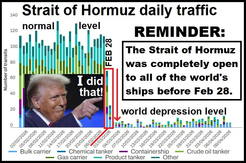
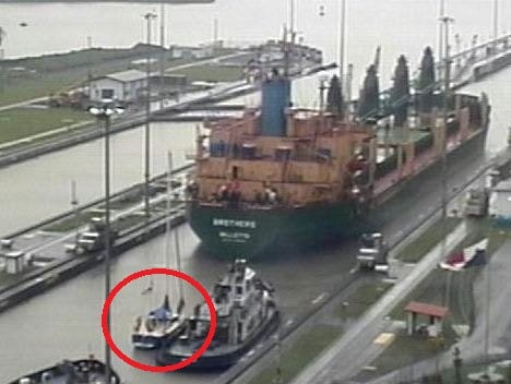
For the sake of comparison, about 35 ships over 50,000 tons converge on or depart from the Panama Canal approaches daily. Only three or four ships over 100,000 tons use the Panama Canal per day. I’ve been through it on sailboats three times. On both the Pacific and Atlantic ends, it looks like all the ships in the world are coming together. And this traffic is nothing compared to what should be passing through the Strait of Hormuz every day, in numbers or in the size and tonnage of the ships. Persian Gulf VLCCs make the ship ahead of my boat seem like a toy.
Maybe I’m wrong, and two-way traffic would be possible, if risky. But now add in the risk of Iranian missiles or drones, and ships taking emergency evasive actions. Hint: 300,000 ton VLCCs moving at 12 knots do not turn like Ferraris, and they essentially have no brakes. They basically just plan long in advance how to coast to a stop in safe place, where large tugs will take over. A full emergency crash stop, engine in full reverse, takes two miles!
The Navy’s Case
So far I’ve made the case against the southern Inshore Traffic Route. Next, I’ll make the U.S. Navy’s case for it.
So why would the U.S. Navy even consider offering any form of safe passage through the risky Inshore Route? Well, first of all, it’s as far as a merchant ship, tanker or warship can get from Iran on the way in or out of the Persian Gulf. Greater distance means more warning time for incoming Iranian missiles or drones. Not much, but even an extra minute can matter a lot.
But I think the main reason for considering an “air-safety umbrella” over this southern route lies in the geography and topography of the northern tip of Oman. Including it’s offshore islands, the northernmost being the previously mentioned Jazirat Salamah, not seen on this chart. Sure, Iran rings the Strait of Hormuz around 270 degrees of arc, all of it cliffs and mountains, bristling with hidden anti-ship guided missiles and Shahed drones, but the top of Oman is also pretty damn good fighting terrain, or at least defensive terrain.

Just look at this map of the northern tip of Oman, (and it does not even include the rocky islands that are 4 and 5 miles north of it.) From an old SEAL’s point of view, this is just about heaven in many ways. First, there are dozens of rocky cliff-edged coves to anchor patrol boats in, with beaches for your rigid hull inflatables. You can move and relocate and find all-around cover anytime you want, day or night.
Naval Special Warfare is not just the SEALs, it also includes “the boat guys” in SWCC, and SpecWar’s own dedicated drone and ISR wing and commo elements. (Not to mention possibly also some MarSoc Marines and assorted other knuckle-dragging cutthroats and scallywags.) I have no particular recent knowledge, I’m just guessing, but that Musandam Peninsula is not where I would want to go today unless I wanted to meet some very tough and well armed American frogmen and Marines with no illusions about the battle that might be coming at any hour.
Yes, Shahed drones can turn and maneuver, but they are slow, and I think our ISR guys will be ready for them. And being in a cave on the far side of a rocky cliff-sided mountain is very good protection from straight-line missiles.
Now, I’m just going to pull in some pictures to give you an idea of the terrain around the Musandam Peninsula. Like I said, it’s “frogman heaven,” as long as somebody is bringing the water and ice, decent rations, and some smuggled cases of Beera Heineken would certainly not hurt. Too bad there’s an effin’ war going on. Looks like some nice diving, fishing and boating.


And next, some snaps of the Salamah Islands. Lucky guys that pull that duty: Almost no officers! Sometimes none at all. Or only J.O.s, and you can handle them easy. And if anybody from “higher” is coming to visit, you’ll always know well ahead of time. Set up your hooch in a shady cave with a breeze blowing through, and leave us the hell alone until it’s go-time. We’ll find the fish, crabs, lobsters, octopi, clams etc. by the second day. Just bring your spice pack and hot sauce. Frogman heaven.


Novels by Matt Bracken
Bracken’s collection is available from Amazon for Kindle and Audible, but it’s better to get the printed books from him. He’ll sign ’em, Jeff Bezos won’t. And Amazon won’t get two-thirds of your moola. Snail mail works fine, but PayPal is quicker.
 | A guest post by
|
Interesting and informative article - thanks for the maps, which I have not been able to find elsewhere.
Thanks to Matt for posting this thoughtful explanation, and to Peter for hosting.
These routes may be physically practical for some cargo vessels, yet still be commercially uninsurable. Insurance rates have risen from a floor of 1% of hull price to a ceiling of 10%, which changes the commercial calculus -- and you can't dock what isn't insured.
Owners of stranded shipping may be willing to take risks to get them out and we have seen some evidence of that; it doesn't mean they'll bring them back.